Trail Walking La Chaux-du-Dombief - Tour du Pic de L Aigle - Photo
© OpenStreetMap contributors
Length
Length
12.2 km
Max alt
Max alt
991 m
Uphill gradient
Uphill gradient
327 m
Km-Effort
Km-Effort  
16.6 km
Min alt
Min alt
771 m
Downhill gradient
Downhill gradient
327 m
Boucle
Boucle
Yes
Creation date :
2024-09-20 07:23:37.747
Updated on :
2024-09-20 13:26:41.706

(0 Reviews)

Walking
Walking
5h24
Difficulty : Difficult

Scan this QR Code to open this trail in the SityTrail application

FREE GPS app for hiking

Logo SityTrail SityTrail

IGN / Geographical institutes

Download SityTrail from the App Store Download SityTrail from Google Play

Logo SityTrail SityTrail World

The world is yours!

Download SityTrail from the App Store Download SityTrail from Google Play Download SityTrail on Huawei AppGallery

About

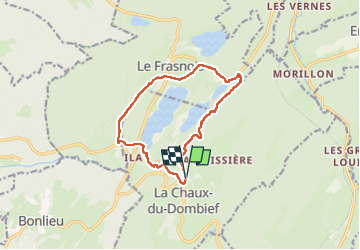
Trail Walking of 12.2 km to be discovered at Bourgogne-Franche-Comté, Jura, La Chaux-du-Dombief. This trail is proposed by pascalmilpas.

Description

du P2 de Chaux de Dombief  descente vers le Lac d Ilay dont on fait le tour par Frasnois
Tres belle et rude montée vers la crête qui domine les Lacs : les belvédères et le Pic de l 'Aigle : points de vue exceptionnels

Elevation profile

Positioning

Country:
France
Region :
Bourgogne-Franche-Comté
Department/Province :
Jura
Municipality :
La Chaux-du-Dombief
Location:
Unknown
Start:(UTM)
722411 ; 5165958 (31T) N.

Trails nearby

Trail Walking Le Frasnois - Cascades du Hérisson et les 4 lacs  - Photo
Walking
GUIDE
mumu.larandonneuse

Walking

Medium
(1)
Le Frasnois, Bourgogne-Franche-Comté, Jura, France
15.4 km | 20 km-effort
4h 35min
No
Trail Walking Menétrux-en-Joux - Cascades du Hérisson 13.7.24 - Photo
Walking
GUIDE
fredetpascale

Walking

Easy
Menétrux-en-Joux, Bourgogne-Franche-Comté, Jura, France
8.5 km | 13 km-effort
2h 30min
No
Trail Walking Le Frasnois - Lac de Narlay - Pic de l'Aigle - Photo
Walking
GUIDE
mumu.larandonneuse

Walking

Medium
Le Frasnois, Bourgogne-Franche-Comté, Jura, France
16.3 km | 22 km-effort
7h 1min
Yes
Trail Walking Le Frasnois - lacs des maclut - Photo
Walking
bonj39

Walking

Very easy
(1)
Le Frasnois, Bourgogne-Franche-Comté, Jura, France
9.6 km | 12.1 km-effort
2h 1min
No
Trail Walking La Chaux-du-Dombief - pic de l''aigle - la Chaux-du-Dombief - Photo
Walking
CharlyG57

Walking

Very easy
(1)
La Chaux-du-Dombief, Bourgogne-Franche-Comté, Jura, France
6.3 km | 9.2 km-effort
Unknown
No
Trail Walking Le Frasnois - La Fromagerie  - Photo
Walking
nana1643

Walking

Medium
Le Frasnois, Bourgogne-Franche-Comté, Jura, France
13.1 km | 16.4 km-effort
3h 27min
Yes
Trail Electric bike Saint-Laurent-en-Grandvaux - 030824 - Photo
Electric bike
ricou1964

Electric bike

Medium
(1)
Saint-Laurent-en-Grandvaux, Bourgogne-Franche-Comté, Jura, France
49 km | 61 km-effort
Unknown
Yes
Trail Walking Le Frasnois - Pic de l'Aigle 14.7.24 - Photo
Walking
GUIDE
fredetpascale

Walking

Easy
Le Frasnois, Bourgogne-Franche-Comté, Jura, France
9.5 km | 13.7 km-effort
3h 0min
Yes
Trail Horseback riding Le Frasnois - suuntoapp-HorsebackRiding-2024-05-22T07-07-14Z - Photo
Horseback riding
GUIDE
holtzv

Horseback riding

Easy
Le Frasnois, Bourgogne-Franche-Comté, Jura, France
21 km | 26 km-effort
3h 27min
No


Close
My subscriptions